


Editor’s Note: We are pleased to welcome Ajay Raghavendra, PhD back to our pages. Ajay took a sabbatical for service to the country, additional training and paternity leave. We appreciate having him back making each of us smarter about coexisting with our climate.

The operational impact of flying through or avoiding turbulence is consequential. Flying through turbulence is avoided for obvious reasons such as aircraft structural limitations, safety, in-flight service disruptions, and passenger comfort. Avoiding turbulence during pre-flight planning stages may involve a longer routing or flying at a nonoptimal altitude. During flight, pilots typically request amendments to their routing or cruise altitude based on “ride reports” from other aircraft, dispatchers’ insights, or coordination with air traffic control (ATC) for an amended clearance while flying through turbulence. Similar to other aviation weather hazards, turbulent environments should be avoided at best and exposure of aircraft to turbulent environments must be limited.
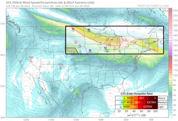
My previous article Beautiful Mountains, but Turbulent Skies discussed mountain-wave turbulence that may exist in the clear or identifiable by the presence of lenticular clouds (lens shaped clouds) or rotor clouds. In this article, we shall review clear-air turbulence (CAT) associated with jet streams. Airliners typically operate at high altitudes for most of the flight. These higher altitudes with thinner air and colder temperatures enable higher true airspeeds (TAS), decrease fuel burn, and faster ground speeds if traveling with a tailwind. However, the strong horizontally and vertically windshear including speed shear across the jet stream, and undulations in the jet stream pave the way for an environment ripe for CAT. In the embedded image, we observe higher values of Eddy Dissipation Rates indicative of moderate/severe turbulence along the jet stream situated over the northeastern U.S.A.
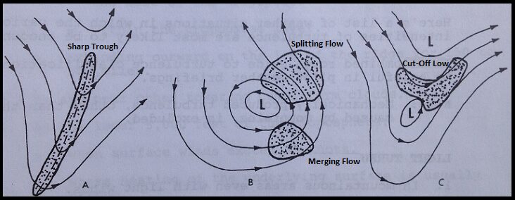
For CAT associated with jet streams, a “big picture” approach to weather is crucial. Studying the upper air charts and understanding how the jet stream is morphing for the duration of the flight can help you anticipate the presence of turbulence. This is especially crucial if you are operating in a sector with few aircraft operating near your route yielding fewer pilot reports (PIREPs), long-distance flights, or near a rapidly changing weather system. These sketches of synoptic scale weather flow patterns show that (A) sharp upper-level trough, and (B and C) cut-off low with convergent or divergent flow patterns are areas susceptible to CAT.


