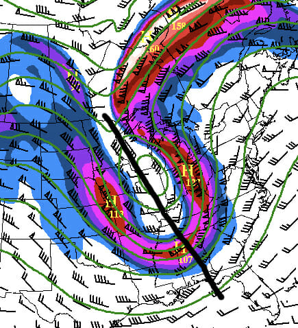
I would not recommend starting off any conversation with this question nor using it as a pick-up line, certainly. That could get you into trouble in a range of social settings. That in mind, you’ll be happy to know that my columns in Aero Crew Newsare not about getting out of (or into) trouble in social settings. They are about keeping you and getting you out of trouble when you’re flying. Negatively tilted troughhas nothing to do with pin-ball either, but after reading this, you might learn that flying in or near these troughs could make you feel like you are a pinball!
Back to Basics
As a review of what you learned working on your private; look for a dip, or a pronounced “sharpness” in upper-level winds at, or above, the FL180 (500 Mb) level. Further, take this idea and observe the axis of the trough’s angle across lines of longitude. If its angle across lines of longitude goes from NW to SE, you have a negatively tilted trough. Why do we care if a trough is negatively tilted? Because, there is the potential for widespread thunderstorms and turbulence in the vicinity of this phenomenon.
According to Meteorologist Jeff Haby (www.theweatherprediction.com), negatively tilted troughs indicate:
- A low-pressure system has reached maturity
- Strong differential advection (middle- and upper-level cool air advecting over low level warm air advection) increases thermodynamic instability
- The presence of vertical wind shear
We can see how awareness of a negatively tilted trough and its location is of value. A picture should be forming in your mind. Meteorologists specifically mention negatively tilted troughs in forecasts and discussions because of their propensity to spawn bad weather. Troughs can be positively tilted or neutrally tilted as well, but these siblings of the negatively tilted trough are not as noteworthy in the formation of inclement weather and are therefore rarely mentioned as a specific weather map feature.
The general consensus, supported by meteorological data, is that negatively tilted troughs often produce outbreaks of severe weather that can often be significant. “These types of troughs produce the most severe weather,” according to www.weather.gov/jetstream/basic. That fact is enough to ensure we pay attention to this variety of trough when we fly.
The reasons for the potential of widespread convective activity include the presence of low-level winds coming from a moisture-laden direction (e.g. SW/Gulf of Mexico) and the positioning of cold NW winds at higher levels above this low-level moisture-laden air. Additionally, since there is a relatively rapid change in wind direction over a relatively short horizontal distance, wind shear is present on a large scale.
With wind shear come a few things: turbulence, sustainability (life span) and the organization of thunderstorms. This is why we look at the weather map before we take off. Specifically, to find troughs of any kind, look at the winds aloft charts. We should do this before every flight.
The proliferation of severe weather is encouraged by the juxtaposition of a variety of weather phenomena. For the perfect storm to form, multiples must exist over a given area. In the case of a negatively tilted trough, two of the prime culprits in the formation of severe weather are present. Though you are not guaranteed widespread severe weather with negatively tilted troughs, you may be on the way to an encounter!
Flight Plan for Success! Literally.
- Be on guard for potentially widespread and possibly severe turbulence. Altitude deviations may or may not work for finding a better ride. Consider lateral deviations to find a better ride, too.
- Be on the lookout for widespread, organized convection.
- Tend to be juxtaposed with negatively tilted troughs
- Help your overall preflight and inflight planning regarding thunderstorm activity
Your knowledge of the basics surrounding negatively tilted troughs, their existence on a weather map and their location is paramount to flight safety. With increased information, our mental model and situational awareness are improved which heightens our alertness and ability to explore options for routing, when necessary.
In future articles, I will help you hone in on some aviation thunderstorm forecast products that you may find helpful.


