In this article, I will describe some of the criteria that I think you should use in determining whether a thunderstorm is occurring at an airport. I can already hear you saying, “That’s easy! A METAR reports one.” Well, not so fast. The criteria used to report the presence of a thunderstorm relative to the airport are wide and varied. This article will not review those criteria. That’s the job of the Aviation Weather handbook. What I will describe is a best attempt to make sense of what is really going on at the airport (with respect to arrivals). The mere inclusion of “TS” in a METAR is no guarantee a thunderstorm is occurring. I hope to assist your in-flight decision making by considering more than just “TS” in a METAR.
Unfortunately, the sensible weather at an airport can be misconstrued from the varied reporting requirements that go into reporting the presence of a thunderstorm at or near the airport. This difficulty in deciphering the sensible weather at the airport could lead to premature diversions or risky flight operations.
Plainly and clearly, I am not giving you any advice or instruction. I’d like you to think of this as an effort to mentor. (Now that legal disclaimers are taken care of… )
THERE YOU ARE
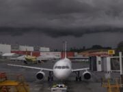
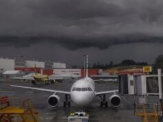
Imagine yourself making your way through angry cumulus clouds 100 NM from destination. The radar is dutifully doing its job. It’s painting a mess of fully mature convective weather right around destination. You’re in solid IMC.
Airborne weather radars’ resolution (precision of viewing) or ability to pinpoint where the cell is, relative to the airport, are better the closer you are – maybe best when you’re too close to the area in question. This is the crux of the dilemma. Said another way, gaps in the weather can best be identified closer to the area. The bottom line? You don’t know whether you should come in closer for a look or bail out now.
IT’S IN THE METAR – WELL, ALMOST
A METAR is very good at collecting quantitative data; temperature, ceiling, visibility, winds and a treasure trove of other specific bits of weather data. Within its capacity is the ability of a METAR to capture the presence of lightning. Lightning can be described by its frequency and distance relative to the field (VC, OVHD, etc.). While this is informative, it still does not capture the essence of convective activity relative to the place you are trying to land. One vaguery of this issue is that lighting and thunder are detectable from relatively far distances. This could lead to an implication that a raging thunderstorm is occurring at destination when it isn’t really the case. In this situation, you might opine, “Well, we are getting kicked around, picking our way through build-ups, why keep going to a place that’s reporting a thunderstorm?” That’s good logic, but it may be incorrect.
WHAT SHOULD YOU CONSIDER?
In no way am I suggesting that you discount METARS when it comes to diagnosing a thunderstorm at an airport. I am suggesting that you consider it in conjunction with the other elements of thunderstorms, and I believe most importantly, the trends in various weather phenomena.
Among the things to consider when deciding if a particular airport is experiencing a thunderstorm are:
- Wind speed, direction and gusts. Presence and trend.
- Presence of wind shear and/or microburst.
- Rain and its intensity. Trend.
- Visibility. Trend.
- Ceiling. Trend.
- Changeability. Special? Rapid changes to the ATIS?
- ATC radar. Always remember, this is only a secondary task for the ATC controllers.
- TREND. TREND. TREND. Did I mention trend?
The presence of lightning or any of the aforementioned weather parameters are not exclusive indicators of a thunderstorm. Each could exist independently of a thunderstorm. Alone, each COULD be hazardous. Together, they ARE hazardous. As the PIC, it’s your job to decipher what is safe and what may not be. You should be considering all of these factors independently and together before operating an airplane close to the ground.
ACARS
If your airplane has ACARS and you suspect the presence of convection, you should have ACARS on AUTO update. This will allow this resource to rapidly capture and report changing conditions and imply the approach, presence or departure of a hazardous convective cell. If you do not have ACARS, be particularly attuned to rapidly changing ATIS codes for a given airport. This has the same effect – capturing the hazardous weather. It’s worthy to note that the trend and speed at which weather is evolving is a very telling aspect!
SUMMARY.
As pilots, we all know the Golden Rule of thunderstorms and flying. It is my intention to share additional viewpoints and aspects to thunderstorm flying – particularly at the Part 121 level. Remember, METARS have limitations and it is your job to keep that in mind and use it in conjunction with other indicators of convective weather. Thunderstorms are unpredictable, so as responsible pilots, we need to employ various sources of data and be able to analyze weather phenomena outside the capabilities of a METAR report.


