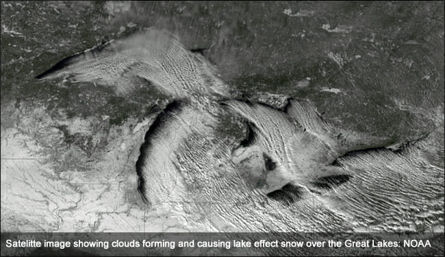
It is that time of year, Lake Effect snow (LES) and its hazards are upon us. Here, I’ll briefly address the science behind this phenomenon. Hopefully, this article will lend some perspective that relates to your pre-flight and in-flight decisions regarding this subject. My goal is for you to be at a heightened state of awareness the next time you go up against this flight hazard.
Ingredients
Lake Effect snow requires lakes. Or does it? What Lake Effect snow really needs are:
- Warm (relative to the airmass above it) body of water. This provides moisture and buoyancy.
- Cold airmass advecting over it.
- Specific wind direction
- Some lift. (Often, it is orographic lift provided by the prevailing wind being lifted by the shore/landmass.)
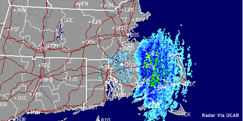
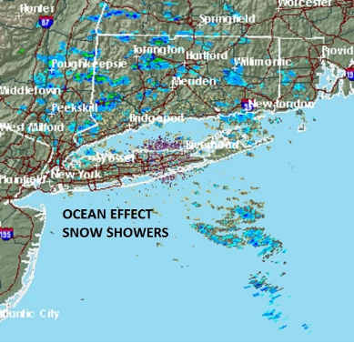
Incidentally, you can find Lake Effect-like snow phenomenon in such places as Cape Cod, Long Island and south of Long Island itself. In these cases, Lake Effect snow is referred to as Ocean Effect and gets its supply of warm water from Cape Cod Bay, Long Island Sound and the Atlantic Ocean. We do not often hear about Ocean Effect snows because these impact smaller populations than the notorious Great Lakes variety.
Winter convection
The process and ingredients by which LES forms should sound familiar. The only reason LES does not become a thunderstorm is that often, during the colder months, there is not enough buoyancy in the atmosphere to support taller clouds. LES clouds are cumulus in nature, but often not very tall.
However, there can be thundersnow – a thunderstorm in which snow, not rain, is the prevailing precipitation. Sometimes, LES can be part of what is called “low-topped convection.” These are simply cumulus clouds that only reach altitudes in the teens to twenties (x thousand).
What’s the fetch?
A key ingredient needed to set this into motion, is wind direction. If the orientation of the wind is over land, then water then land, Lake or Ocean Effect snows can occur, often in earnest. The surface distance over which the prevailing wind travels is a big factor – not just in LES formation, but in how much snow is dumped. This distance across the given body of water over which the wind blows in a single direction is referred to as “fetch.”
How LES affects you in flight
In my opinion, the single biggest hazard of Lake Effect snow to airplanes is its potential for sudden onset. One minute it is better than 5000 and 5 and the next minute it is CAT II minimums. As a conscientious pilot, while flying into airports prone to LES, your situational awareness needs to be at a high level. Brief and set-up your navigational resources for the possibility of low visibility approaches even when the airport is VFR.
If you have not done a thorough pre-flight weather briefing, your ability to know about and see (visually or on radar) LES while flying is pretty much nil. You need to know about its potentiality in the first place. If you are ready, you are safer. If you are not, you’re more at risk. Know and brief!
The second biggest hazard to LES (in my opinion) is wind shear. Often, LES starts in the form of a squall. Brief and expect wind shear.
Thirdly, field conditions and their rapid change can be an additional and significant hazard. A bare and dry runway could experience rapidly deteriorating conditions. You may not want to be the first aircraft to land on a freshly coated runway. Consider holding. (By the way, did you consider hold fuel when you launched the flight in the first place?)
It is not a lost cause
The TAF is your first line of defense in dealing with LES. It obviously tells you the presence of low visibility, wind shear, precipitation type and intensity. That said, the TAF does not directly inform you from where all these hazards are coming. The weather radar you check before flight can help. An inherent flaw of a TAF is that while it tells you the weather, it does not tell you the nature or flavor. The knowledge of whether atmospheric hazards are synoptic or mesoscale is especially important to know. You gain this knowledge with a thorough weather briefing. It’s not just important to know that the weather is going to be good or bad, but why.
Remember that use of the radar picture, the satellite, and our typical weather products should be combined to assess the possibility and/or existence of LES.
One additional tool that you could use to familiarize yourself with LES are called “Lake Effect Snow Advisories.” Consult https://www.weather.gov/. These, along with other weather advisory, watch and warning products issued by NWS can be used in conjunction with your aviation weather products to alert you to LES. See the NWS definition here.
In closing
The good news about LES is that it can be very transient in nature. A change in wind direction can stop it from occurring rather quickly. If you have hold fuel and some patience – great! Just note, sometimes LES never seems to stop but, there is good news here. The precipitation and weather gradients are often very drastic which means a place of retreat is often not far away.
This mantra should apply always: A well briefed pilot is a great safety device. This applies to both the weather briefing and the in-flight cockpit briefing. In cases of LES, these two matters take great prevalence. If your situational awareness is what it should be, briefing routines should take on heightened priorities when dealing with Lake Effect snow.
























I was looking at your post on Lake Effect Snow.
I live in the Great Lakes area and wrote an extensive article entitled 14 Areas Around the Great Lakes With High Lake Effect Snow – How Does it Happen https://thumbwind.com/2021/03/07/great-lakes-lake-effect-snow/
You might find some information and resources to give your readers more background on just how much snow we get here around the Great Lakes. I hope you will consider it.
Mike