























































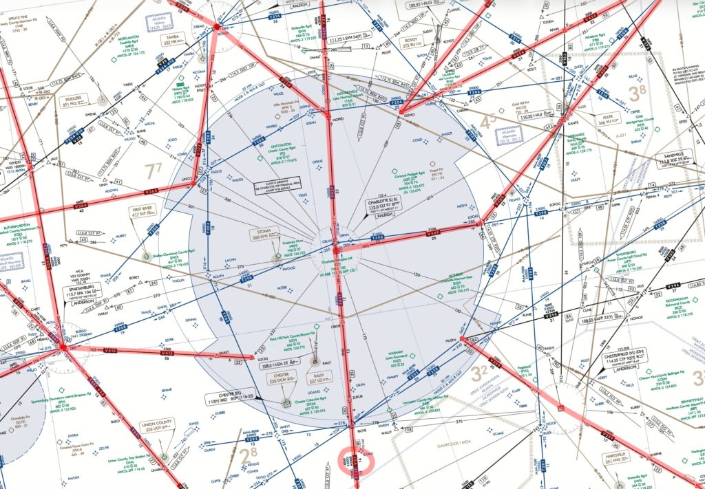
The FAA has proposed a significant set of changes to a dozen and a half legacy VOR federal airways in the eastern United States as part of its ongoing transition to a leaner backup navigation network under the VOR Minimum Operational Network (MON) program. In a Notice of Proposed Rulemaking (NPRM) published in the Federal Register, the agency outlines how decommissioning three key NAVAIDs—Charlotte, NC (CLT) VOR/DME, Foothills, SC (ODF) VOR/DME, and Holston Mountain, TN (HMV) VORTAC—in December 2026 will drive route amendments, gaps, and redesigns to keep the National Airspace System operating safely and efficiently.
The proposed rule would amend 14 CFR Part 71 to revise 14 domestic VOR Federal airways: V–16, V–35, V–37, V–53, V–133, V–136, V–143, V–259, V–310, V–364, V–409, V–415, V–454, and V–605. In many cases, the segments that rely directly on the CLT, ODF, or HMV facilities would either be removed—shortening the airway—or broken, creating gaps bridged by adjacent routes or by ATC radar vectors. For several airways, including V–133, V–143, V–454, and V–605, the FAA proposes to “redesign” them by redefining critical fixes with radials from remaining VORs so that the structure and usability of the routes are preserved even after the original NAVAID goes dark.
In the broader context of the VOR Minimum Operational Network initiative, the proposed changes to these eastern U.S. airways reflect steady, systemwide progress toward a leaner, predominantly GPS‑based infrastructure. As of January 8, the program has discontinued 212 VORs and has an additional 88 facilities identified for future decommission, underscoring that the Charlotte, Foothills, and Holston Mountain sites are part of a much larger, long‑term transition strategy rather than isolated removals. View the entire list here: https://aerocrewnews.com/85v9 This pace of decommissioning highlights why the FAA is systematically redesigning affected routes, redefining fixes, and expanding RNAV alternatives: the agency is restructuring the legacy VOR network into a smaller, strategically located backbone that can serve as a robust backup when satellite navigation is unavailable.
A major theme of the NPRM is preserving continuity of IFR navigation options while no longer maintaining a dense, legacy VOR network that the FAA considers more extensive than necessary in a GPS‑enabled NAS. The agency notes that affected traffic can use adjacent VOR airways such as V–20, V–45, V–296, V–466, and V–470, or take advantage of an expanding grid of low‑altitude RNAV “T‑routes” like T–202, T–203, T–215, and others to cross the region. IFR pilots with RNAV‑equipped aircraft can also navigate point‑to‑point via existing fixes that will remain, while VFR pilots who prefer to follow airways can request ATC services to traverse or avoid the impacted area.





A natural question behind this proposal is whether it is wise to decommission a backup navigation aid in an era when GPS has become the primary means of IFR navigation and is increasingly subject to jamming and spoofing concerns. The FAA’s VOR MON strategy is explicitly designed so the system does not rely solely on GPS: instead of eliminating VORs outright, it concentrates a smaller network to act as a terrestrial safety net during GPS interference, allowing aircraft at or above MON altitudes to navigate to a suitable airport and fly a ground‑based approach without satellite navigation. Aviation as a whole is built on redundancy, from multiple independent navigation sensors to layered procedures and ATC services, and the MON concept aims to preserve that layered resilience while retiring underused or overlapping facilities rather than all ground‑based aids. At the same time, the growing reality of GPS interference underscores why many pilots and industry groups argue that the remaining VOR backbone must be robust, well‑maintained, and thoughtfully located—because in a large‑scale satellite outage, those “old‑fashioned” needles may once again be the last line of precise guidance.
Legally, the proposal rests on the FAA’s statutory charge under 49 U.S.C. 40103 to assign and manage airspace use to ensure safety and efficiency, authority that Part 71 implements by defining airspace, routes, and reporting points. The agency characterizes the action as a routine technical update to keep charts and route descriptions aligned with the evolving NAVAID network and concludes it is not a “significant” regulatory action under Executive Order 12866 and will not have a significant economic impact on a substantial number of small entities. An environmental analysis under FAA Order 1050.1G will be completed before any final rule, and the proposal would be codified by amending FAA Order JO 7400.11K, which is incorporated by reference into Part 71 on an annual cycle.
Comments on the NPRM are due by April 20, 2026, and can be submitted electronically via Regulations.gov under Docket No. FAA–2026–2452, by mail, hand delivery, or fax to the Department of Transportation’s Docket Operations office in Washington, DC. All comments, including any personal information, will be posted without edit on Regulations.gov consistent with DOT’s system of records notice DOT/ALL–14, and the FAA will consider all timely feedback—and late comments when practical—before issuing any final amendments.
To dive into all the technical details, proposed route descriptions, and the FAA’s full narrative on these airspace changes, read the complete article and source material at: https://aerocrewnews.com/roff.